MIZ (MARGINAL ICE ZONE) STUDY

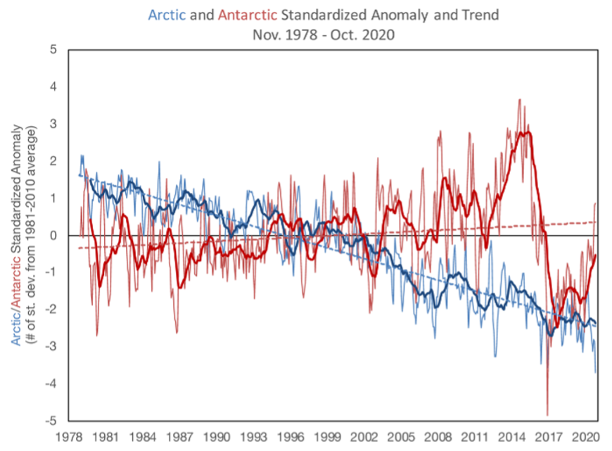
 This graph shows monthly extent (thin lines) for Arctic (blue) and Antarctic (red) and 12-month trailing average (thick lines) for standardized anomalies (departure from the 1981 to 2010 average in each month divided by the 1981 to 2010 standard deviation for the month). The linear trend is overlaid in dashed lines.
 Credit: W. Meier, NSIDC https://nsidc.org/arcticseaicenews/
 This graph shows monthly extent (thin lines) for Arctic (blue) and Antarctic (red) and 12-month trailing average (thick lines) for standardized anomalies (departure from the 1981 to 2010 average in each month divided by the 1981 to 2010 standard deviation for the month). The linear trend is overlaid in dashed lines. Credit: W. Meier, NSIDC https://nsidc.org/arcticseaicenews/

THE MIZ STUDY

The Marginal Ice Zone (MIZ) Study is a comprehensive, multi-disciplinary, and collaborative Antarctic science program that focuses on one of the fastest-changing regions of the Southern Ocean.

This science project has been designed to provide samples, data, and synergistic analysis to understand the (East) Antarctic marginal ice zone (MIZ), and its efficiency in promoting (or reducing) ocean, atmosphere and ecosystem functions.

The MIZ Study will deliver essential information and material for government policy and meet international obligations, including long-term monitoring, in-situ* datasets, and Earth System analysis.

*in-situ (collected in the field during an expedition / as opposed to remotely sensed) datasets

DEFINITION OF THE MIZ

MIZ (Marginal Ice Zone) is the transition from compact sea ice to open ocean. The definition is related to both sea-ice concentration and wave effect on sea ice, usually  a combination of both.

Wave and sea ice interactions in the marginal ice zone: Waves are attenuated by sea ice. They contribute to dynamics, growth, and melt within the pack. Waves impacti established sea ice most obviously via changes to floe size i.e. the size distribution of plates of ice that give a cracked eggshell appearance to the pack. 

Moving from left to right in the figure, waves interact with and contribute to frazil ice which is produced by cooling ocean water. Frazil is aggregated to a point where ice reaches a maximum concentration and local sections of ice raft on top of each other to produce thick ice that eventually congeals into solid blocks of sea ice. Wave properties, including reflection, damping, and production due to wind fetch over open waters are modified throughout this process.

From E3SM https://e3sm.org/e3sm-next-generation-development-for-coastal-waves/Figure 2,  – adapted from Dai et al. (2019) and Sutherland and Dumont (2018).
Wave and sea ice interactions in the marginal ice zone: Waves are attenuated by sea ice. They contribute to dynamics, growth, and melt within the pack. Waves impacti established sea ice most obviously via changes to floe size i.e. the size distribution of plates of ice that give a cracked eggshell appearance to the pack. Moving from left to right in the figure, waves interact with and contribute to frazil ice which is produced by cooling ocean water. Frazil is aggregated to a point where ice reaches a maximum concentration and local sections of ice raft on top of each other to produce thick ice that eventually congeals into solid blocks of sea ice. Wave properties, including reflection, damping, and production due to wind fetch over open waters are modified throughout this process. From E3SM https://e3sm.org/e3sm-next-generation-development-for-coastal-waves/Figure 2, – adapted from Dai et al. (2019) and Sutherland and Dumont (2018).
Project Summary

MIZ Study Project Summary

The MIZ Study is multi-disciplinary science, probing natural pathways of crucial elements within coupled systems.

The MIZ Study focuses on numerical modelling and detailed observations of system interactions.

These data will be used to calibrate Earth System models to Southern Ocean conditions, thereby tangibly improving forecasts of climate change impacts on ecosystem functions and enhancing weather prediction.

The research is critical due to complex interactions with Earth system components. Seasonal cycles are driven by sea ice expansion and retreat. Sea ice isolates atmosphere from ocean and affects flux of momentum, thermal energy, freshwater, and gases.

The effectiveness of sea ice in regulating the carbon cycle remains a topic of discussion [Gupta et al., 2020]. However, the role of Southern Ocean sea-ice in supporting primary production [Taylor et al., 2013] and Antarctic krill is now well accepted [Kohlbach et al., 2017].

The boundary between ocean and atmosphere is the interface for exchange. Processes that govern the (upper) ocean-sea ice-snow-atmosphere interactions determine Southern Ocean circulation, heat, and acidification.

RSV Nuyina will be a manned and autonomous observatory. Sensors include a Rhoen mast deployed downward from the Forward Outboard Deployment System [FODS] and a complete sensor set for eddy kinematic measurements of the ocean-ice-snow-atmosphere boundary.

The MIZ Study will provide a direct opportunity for Australia’s expanding space sector to adopt Earth Observation science support as one of its future pathways. Such collaborative and compliant research builds partnerships across government, university, industry, and environmental organisations.

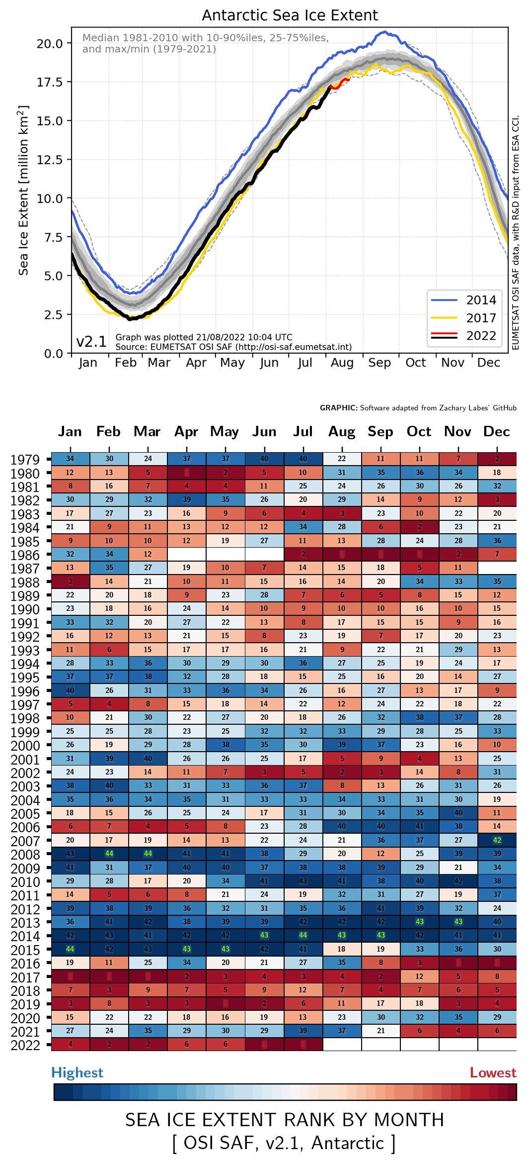
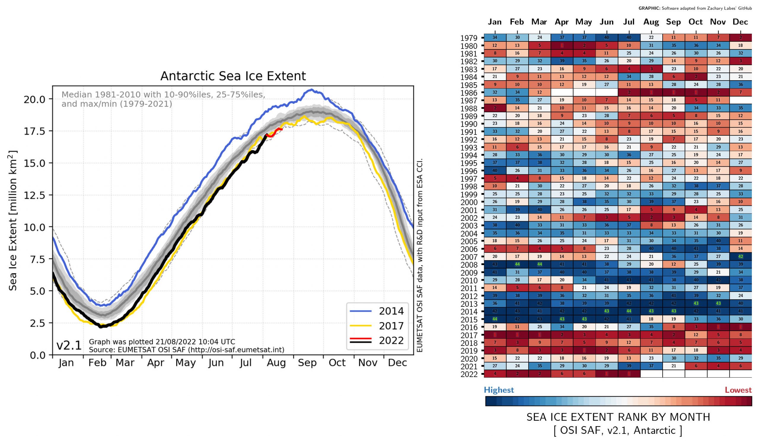
EUMETSAT Ocean and Sea Ice Satellite Application Facility, Sea ice index 1979-onwards (v2.1, 2020), OSI-420, Accessed 2022-08-22

Sea Ice Extent (SIE) is defined as the area covered by a significant amount of sea ice, that is the area of ocean covered with more than 15% Sea Ice Concentration (SIC).
EUMETSAT Ocean and Sea Ice Satellite Application Facility, Sea ice index 1979-onwards (v2.1, 2020), OSI-420, Accessed 2022-08-22 Sea Ice Extent (SIE) is defined as the area covered by a significant amount of sea ice, that is the area of ocean covered with more than 15% Sea Ice Concentration (SIC).
Organisation

MIZ Study Organisation

Scientific management of the MIZ Study has four tiers.

Project coordination
Individual researchers and research groups from ACEAS and AAPP, coordinated by Dr. Petra Heil (AAPP) and Dr. Delphine Lannuzel (ACEAS).

Work packages
The projects are organized around thematic work packages [WPs]: Each WP has two leads to facilitate the cross-fertilisation of ideas.

Science Steering Group
A Scientific Steering Committee from ACEAS and AAPP oversees the integration of scientific objectives and ensures strategic alignment and timeliness of tasks.

Science Advisory Board
Outside ACEAS and AAPP partnerships, an Advisory Panel of leading international researchers provide

  • Independent scrutiny of the project objectives, methods, and progress
  • A sounding board for strategic decisions
  • Review of excellence, relevance, and timeliness of research outcomes
  • Broadcasting of EAMIZ outcomes to the wider international science and end-user communities.

Australian Antarctic Program Partnership

The Australian Antarctic Program Partnership (AAPP) is a partnership of Australia’s leading Antarctic research institutions supported by the Australian Government Antarctic Science Collaboration Initiative. The AAPP will improve our understanding of the role of the Antarctic and Southern Ocean within the global climate system and its implications for marine ecosystems.

Australian Centre for Excellence in Antarctic Science

The Australian Centre for Excellence in Antarctic Science (ACEAS) is a collaboration between Australian universities, government agencies and international research institutions supported by the Australian Research Council (Grant ID SR200100008). The goals of ACEAS is to help the world community prepare for climate risks emerging from East Antarctica and the Southern Ocean by integrating knowledge of the ocean, atmosphere, cryosphere and ecosystems, and their interplay.

Collaboration

MIZ Study Collaborators

Colleagues in partner projects (AAPP and ACEAS) link to space agencies supporting Earth Observations and Numerical Modelling (hindcasting, forecasting, and climate simulations).


MIZ Study research contributes to the following international activities:

  • Scientific Committee on Antarctic Research [SCAR]
  • Scientific Committee on Oceanic Research [SCOR]
  • World Climate Research Program [WCRP] 's Climate in the Cryosphere [CliC] project Biogeochemical Exchange Processes at the Sea-Ice Interfaces [BEPSII]
  • Antarctic Sea Ice and Climate Processes [ASPeCt]
  • World Meteorological Organisation’s [WMO] Global Cryosphere Watch [GCW].

Collaborators include:

The MIZ Study finds its match in the UK-led project "Drivers and Effects of Fluctuations in sea Ice in the ANTarctic" [DEFIANT] in the Weddell Sea on the RSS Sir David Attenborough [BAS], and regular research cruises led by the Alfred Wegener Institute [AWI] on the FS Polarstern.

USERS

Uses of the MIZ Study

MIZ Study data will be used to develop, calibrate and validate Earth System models.

The suite of data variables caters to:

  • WMO Global Climate Observing System [GCOS]
  • Essential Climate Variables [ECV]

and will be used to:

  • assess satellite products
  • calibrate and validate ('cal/val') remote sensing
  • inform planned missions.

Planned space missions include:

European Space Agency [ESA]'s RADAR altimeter CryoSat-2 simultaneously with National Aeronautics and Space Administration (NASA]'s LASER altimeter ICESat-2.

Both missions provide repeat observations of sea-ice freeboard and total sea-ice surface elevation, from which we extrapolate sea-ice thickness.

Similarly, ESA will run the Cryo2ICE project, changing the orbit of CryoSat-2 to align with NASA's ICESat-2 over Antarctica to collect RADAR and LIDAR measurements of the same sea ice at nearly the same time.

ESA also plans the Copernicus Polar Ice and Snow Topography Altimeter [CRISTAL] mission, carrying both a dual-frequency RADAR altimeter and microwave radiometer, to measure sea-ice thickness, overlying snow depth, and total sea-ice elevation.

Communication Plan

Communication Plan

The purpose of the MIZ study website is to plan and implement the MIZ Study project in a forum that is collaborative, open and FAIR (findable, accessible, interoperable and reusable): As such, this website is and will continue to be a work in progress.

At first, this website is a framework – an empty ‘wireframe’ flagging aspects of scientific planning that each work package will need to address and then compile to achieve an overview of the voyage.

Whilst we didn’t say ‘led from the bottom-up’, if everyone agrees on a way to communicate, and then participates by detailing their requirements in the forms to be provided via that portal (e.g. Air table), then

the communication / management process will facilitate individual researchers and research groups (project teams) realise their goals.

When plans for each project element have been developed, the website will be the place to share those plans.

Then, during the MIZ voyage, as the objectives are being accomplished, the website will track those milestones through data processing and data description to data sharing according to the data management plan.

This website will include both scientific and logistic methods for the MIZ Study.

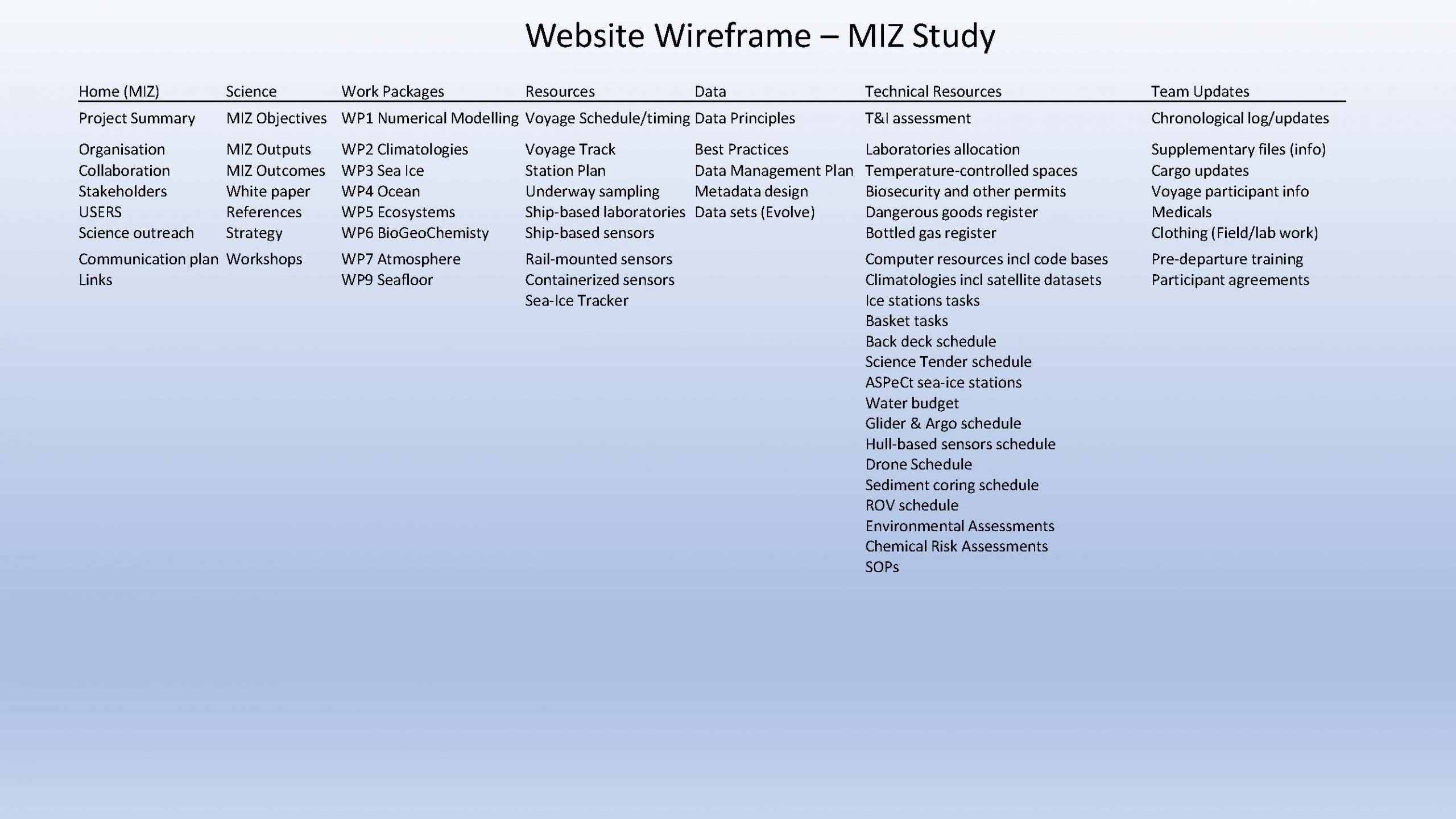
Overview of the MIZ Study website. Home, science and work package tabs are general information about the MIZ Study. Resources, data, technical resources and team update tabs are for project implementation.